“KEEP CLOSE TO NATURE’S HEART AND BREAK CLEAR AWAY ONCE IN A WHILE. CLIMB A MOUNTAIN OR SPEND A WEEK IN THE WOODS. WASH YOUR SPIRIT CLEAN” – JOHN MUIR
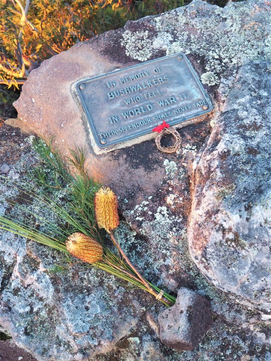
Splendour Rock in the Wild Dog Mountains is a spectacular lookout on the southern end of Mt. Dingo. It is home to the Bushwalkers War Memorial and a service is held here at dawn every Anzac Day.

Time: 4hrs – 5hrs one way
Distance: 28KM return
Grade: Medium – Difficult
The 2-day hike follows both open fire trail and technical single trail to a camping area on top of Mt. Dingo. It is a challenging track in parts, requiring some rock scrambling and navigation to get you there, but once you’re out on Mt. Dingo enjoying the panoramic views of Lake Burragorang to the east and the Kanangra Walls to the west it will have all been worth it.
GETTING THERE:
The walk starts and ends at Dunphy’s Camp in the Megalong Valley. To get here, drive towards Blackheath and turn left (if coming from Katoomba) across the railway line at Bundarra Street and then immediately left again at Station Street. Follow the road for around 700m and then turn right onto Shipley Road following signs to the Megalong Valley.

The road winds down to the creek passing by a few campgrounds and Six Foot Track. You’ll soon reach an unsealed dirt road where the trip gets a little bit bumpy. You’ll need to pass through 3 gates before you reach Dunphy’s (ensuring you close the gates behind you). After the final gate, follow the track up the hill and turn left at the T-intersection. The camping area is to the right at the top of the hill with plenty of room for parking and camping.

TRACK NOTES:
From the parking area, head left away from the campground over the gate and left again up the steep hill along the Bellbird Ridge Trail. You’ll pass a turn off for Bellbird View Lookout before coming to a junction in the Medlow Gap Trail (approx. 15/20 minute walk). Turn right here and follow the fire trail until to reach a large clearing at Medlow Gap (approx. 60/75 minutes) – a good spot to have a quick break. To the left there are signs for Taros Ladder and Narrowneck/Katoomba and to the right you will notice another locked gate further down the trail. Head towards and through the gate and follow the trail for another 600m until you see a sign on the right indicating the distances to Mobbs Swamp, Cox’s River and Kanangra Walls.

After 1.5km you’ll reach a clearing on top of Black Horse Ridge, with tracks heading in (supposedly) 5 directions (I’ve only ever seen 4 myself) – continue straight through here. A further 15/20 minutes you’ll reach a 3-way junction and again continue straight through and after a 10/15 minutes you’ll reach Mobbs Swamp, a large clearing and camping area. This will be the last area to collect water if you need it before the climb to Mt. Dingo. Again, another good area for a quick if you need one.

It’s only 2KM from Mobbs Swamp to Splendour Rock, but this last part can take about an hour when carrying heavy packs. Follow the track straight through Mobbs Swamp and the trail will twist along for about half an hour before you hit a T-intersection. Turn left here and prepare for the climb up Mt. Dingo. Best to take is easy here as it is steep in parts and often slippery due to loose rock and fallen leaves. Eventually you’ll come face-to-face with a rock wall and the track looks like it heads off to the left, but don’t be fooled! If you look up at the rock face you’ll notice an arrow pointing up – this is where you climb. This short rock scramble will bring you up onto Mt. Dingo. The track heads off to the right and you’ll notice array of campsites as you mosey along. Pick a spot to set up and go check out the Bushwalkers War Memorial plaque and incredible views from Splendour Rock – don’t forget to sign the guestbook!

ANZAC DAY DAWN SERVICE:
At 6:00AM on Splendour Rock the Anzac Day dawn service commences. This year we had a trumpeter, piper and school choir join us! It truly is an experience unlike any other as fellow bushwalkers gather and commemorate those who fell in World War II.


“Their splendour shall never fade. Lest we forget.”

ALTERNATIVE ROUTES:
For those who are comfortable with heading back to Dunphy’s the way they came in, this option is the most straight forward.
There are various other ways of reaching or returning from Splendour Rock. I would definitely recommenced getting hold of Myles Dunphy’s Gangerang and Wild Dog Mountains Sketch Map, as most of the tracks in the area are marked.


Reblogged this on Lincoln Life Blog.
LikeLiked by 1 person
Thank you for sharing! 🙂
LikeLiked by 1 person
no probs, it’s a great post.
LikeLiked by 1 person
What a great place to be on ANZAC Day!!
LikeLiked by 1 person
It truly is Debbie! 🙂
LikeLiked by 1 person
Haha! I have the same tin mug! 😂 Great post!
LikeLiked by 1 person
I love it!! 🙂 Thank you
LikeLiked by 1 person